
Hydrodynamic and Morphodynamic Modeling for Dredging Feasibility in a River System
Integrated 2D hydrodynamic and sediment-transport modeling to assess the feasibility, impacts, and maintenance requirements of dredging interventions in a complex river reach.
Overview
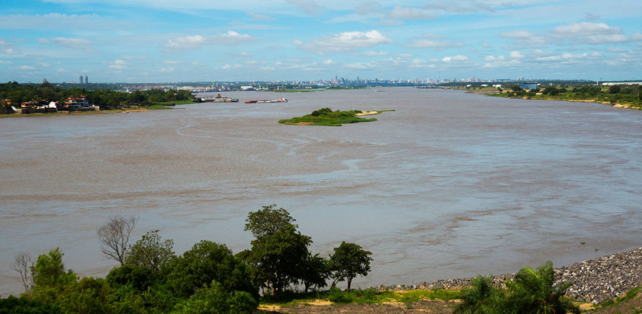
A river navigation corridor presented several shallow zones (“critical passes”) where sediment deposition restricted transit and required potential dredging interventions. Authorities sought a rigorous evaluation of the hydraulic feasibility, environmental impact, and expected maintenance dredging volumes associated with alternative interventions.
HCS conducted a comprehensive 2D hydrodynamic and morphodynamic modeling study, examining flow conditions under multiple hydrological scenarios, assessing the effects of proposed dredging options, and estimating medium-term sedimentation patterns to support decision-making.
The Challenge
The study reach is characterized by:
- Strong interactions between the main river and a secondary channel
- Highly variable hydrology, including low-flow, medium-flow, and flood conditions
- Significant sediment inputs from upstream tributaries
- Morphological complexity
These processes create fluctuating navigation depths and require periodic interventions. The client needed to understand:
- How different dredging options influence water levels, velocities, and flow distribution
- Whether proposed interventions could improve navigation under low-flow conditions
- Hydraulic forces acting on newly excavated channels during floods
- Expected annual sedimentation as a basis for maintenance-dredging planning
Our Contribution
HCS applied a robust numerical modeling framework that combined hydrodynamics, sediment-transport and morphodynamics.
1. Two-Dimensional Hydrodynamic Modeling
A 2D shallow-water model was implemented using a non-structured mesh with local refinement in critical zones. The model incorporated:
- A digital elevation model combining bathymetry, topographic profiles, and remote sensing data
- Spatially varying roughness (Manning coefficients)
- Boundary conditions defined by observed discharges and water levels
- Representation of both confined and overbank flows under flooding conditions
Model stability, domain configuration, and calibration were documented in detail.
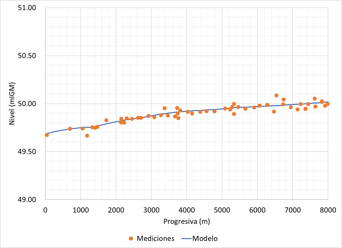
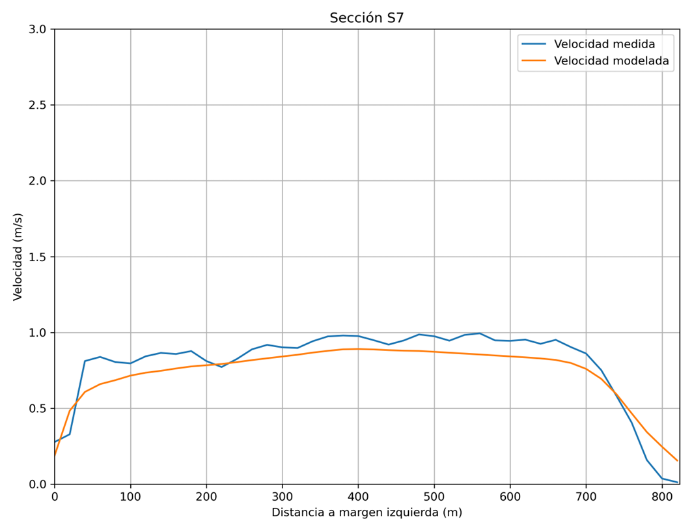
2. Calibration and Validation with Field Measurements
The model was calibrated and validated using:
- Water-surface elevations recorded during a dedicated survey campaign
- Velocity measurements from multiple transects across the river
- Measured tributary inflows
Two independent field campaigns were used to validate both level and velocity fields, achieving very good agreement.
3. Scenario Analysis for Dredging Interventions
Multiple hydrological conditions were modeled:
- Low flow (critical for navigation)
- Medium flow (representative for impact assessment)
- High flow (design of structural protections)
- An extreme low-water event reconstructed from monitoring data
For each hydrological state, different configurations were simulated:
- Current bathymetry
- Channel excavation
- Removal of a local sediment deposit
Results were compared in terms of:
- Flow distribution between the main channel and the secondary channel
- Changes in water levels (typically only centimeters)
- Velocity fields and their spatial redistribution
- Navigation depths along the barge route
In all cases, differences in the main river were small, confirming low hydraulic impact, while excavation produced the expected improvements within the intervention zone.
4. Flood Scenario and Hydraulic Stresses
A flood scenario was modeled to evaluate the stability of the excavated channel. Results included:
- High but manageable velocities within the excavated section
- Flow patterns confirming the adequacy of the modeled domain for flooding conditions
This analysis provided guidance on the type of protection required along exposed margins.
5. Morphodynamic Modeling and Sedimentation Forecasting
The sediment-transport model (coupled to the hydrodynamic solution) represented:
- Bedload and suspended-load transport of coarse sand
- Two granulometric classes based on measured samples (d₅₀ of 250 and 500 µm)
- Bed composition, porosity, settling velocities, and critical shear stresses
- A morphological acceleration factor to simulate yearly evolution
The model evaluated:
- Expected annual sedimentation in the excavated channel
- Sensitivity to grain size, bed thickness, and morphological parameters
- Locations of sediment accumulation and erosion linked to hydraulic conditions
Key Findings
The integrated hydrodynamic–morphodynamic assessment provided the client with:
- High-confidence simulations of water levels and flow velocities under multiple hydrological conditions
- Verification of minimal hydraulic impacts of proposed interventions on the main river flow
- Clear identification of velocity reductions and depth increases within the intervention area
- Quantified hydraulic stresses during flood conditions to support design of bank protections
- Annual sedimentation estimates suitable for planning maintenance dredging
Outcomes and Client Value
HCS delivered a technically robust modeling framework that helped the client:
- Evaluate the hydraulic feasibility of dredging options
- Understand system behavior under critical low-flow conditions
- Prepare for extreme events through predictive modeling
- Estimate maintenance requirements based on morphodynamic evolution
- Make informed decisions regarding long-term navigation improvements
This project illustrates the capacity of HCS to integrate hydrodynamics, sediment transport, and scenario-based analysis for complex river engineering challenges.
Contact
Request a consultation
Have a hydraulic challenge? Let's discuss how we can help.
Call Us
+54 2324 550433